")
Winter does not wait for official declarations. By the time the pattern is obvious in every forecast, the most useful preparation window is already closing.
Why this El Niño forecast matters now

El Niño is not just a patch of warm water in the tropical Pacific. It is one of the planet’s most influential climate patterns, capable of shifting the jet stream, redistributing storm tracks, and altering temperature and rainfall across the United States for months at a time. NOAA’s Climate Prediction Center said in July 2023 that there was a greater than 90% chance El Niño would continue through the Northern Hemisphere winter, and by August it raised confidence even further, projecting better than 95% odds through the December 2023-February 2024 period. The World Meteorological Organization likewise said there was a 90% probability of El Niño continuing through the second half of 2023 and into the upcoming winter season.
That level of confidence matters because El Niño’s strongest influence on U.S. weather typically emerges in winter, not summer. NOAA explains that the pattern tends to peak during the cold season, when its ability to reshape the subtropical jet stream and steer Pacific storms into North America becomes most important. In other words, the headline number is not interesting merely because it sounds large. It matters because the timing lines up with the season when homes, roads, reservoirs, farms, insurers, utilities, and emergency managers are most exposed.
Preparation also matters because El Niño does not act on a blank slate. The United States is entering winters now with warmer background temperatures, stressed water systems in some regions, aging drainage infrastructure, and expensive housing and insurance markets in many coastal and flood-prone communities. NOAA’s assessment of 2024 found the contiguous U.S. had its warmest year on record, underscoring how climate signals now interact with a hotter baseline than in past decades. That can intensify evaporation, accelerate snowmelt timing, and amplify heavy-rain consequences when storms do arrive.
The right lesson is not that every El Niño winter is identical. NOAA repeatedly cautions that El Niño tilts the odds rather than guarantees a specific local outcome. But when forecasters have unusually high confidence in the persistence of the pattern, governments and households should treat that as an advance notice system. It is a prompt to inspect flood channels, review backup power plans, plan for transportation disruptions, and communicate risks before the first damaging storm turns a forecast into a crisis.
What El Niño usually does to U.S. winter weather

The most reliable U.S. winter signal during El Niño is a wetter-than-normal southern tier, especially from parts of California across the Gulf Coast and into the Southeast. NOAA Climate.gov notes that during strong El Niño events, the Gulf Coast and Southeast are consistently wetter than average. Another NOAA analysis of the seven strongest El Niño winters since 1950 found wetter-than-normal conditions along the West Coast and the southern tier of the country, with especially robust signals in the Southeast. That is one reason flood planning belongs near the top of the winter preparation list.
At the same time, the northern half of the country often leans warmer than average, especially over the northern Plains, Great Lakes, and parts of the Northeast, though local variability can still be large. NOAA’s long-running analyses show that El Niño has its strongest influence on U.S. climate in December through February, with the warm signal across the North showing up repeatedly in historical composites. A warmer average winter, however, does not mean a winter without cold snaps. It means the seasonal odds shift, and that can still include bouts of severe cold, snow, and ice between milder stretches.
The West is where public misunderstanding tends to grow fastest. Many Americans hear “El Niño” and immediately assume California will be drenched nonstop. NOAA’s own historical reviews warn against that oversimplification. Some major El Niño winters have delivered damaging California storms, but not every El Niño produces blockbuster rain or mountain snow in every watershed. The strength of the event matters, but so do shorter-term atmospheric patterns that can either reinforce or disrupt the classic signal. That is why water managers and residents should prepare for elevated storm potential without assuming every forecast map will verify exactly.
There are also regions where the signal is weaker or less dependable. NOAA points to a drier tendency in the Ohio Valley and a less reliable dry signal in parts of the Pacific Northwest and northern Rockies during El Niño winters. Alaska can also respond differently than the lower 48. The important takeaway is that El Niño is best understood as a nationwide reweighting of risk. It increases the probability of some hazards, lowers the probability of others, and leaves room for surprises where local weather systems overwhelm the broader climate pattern.
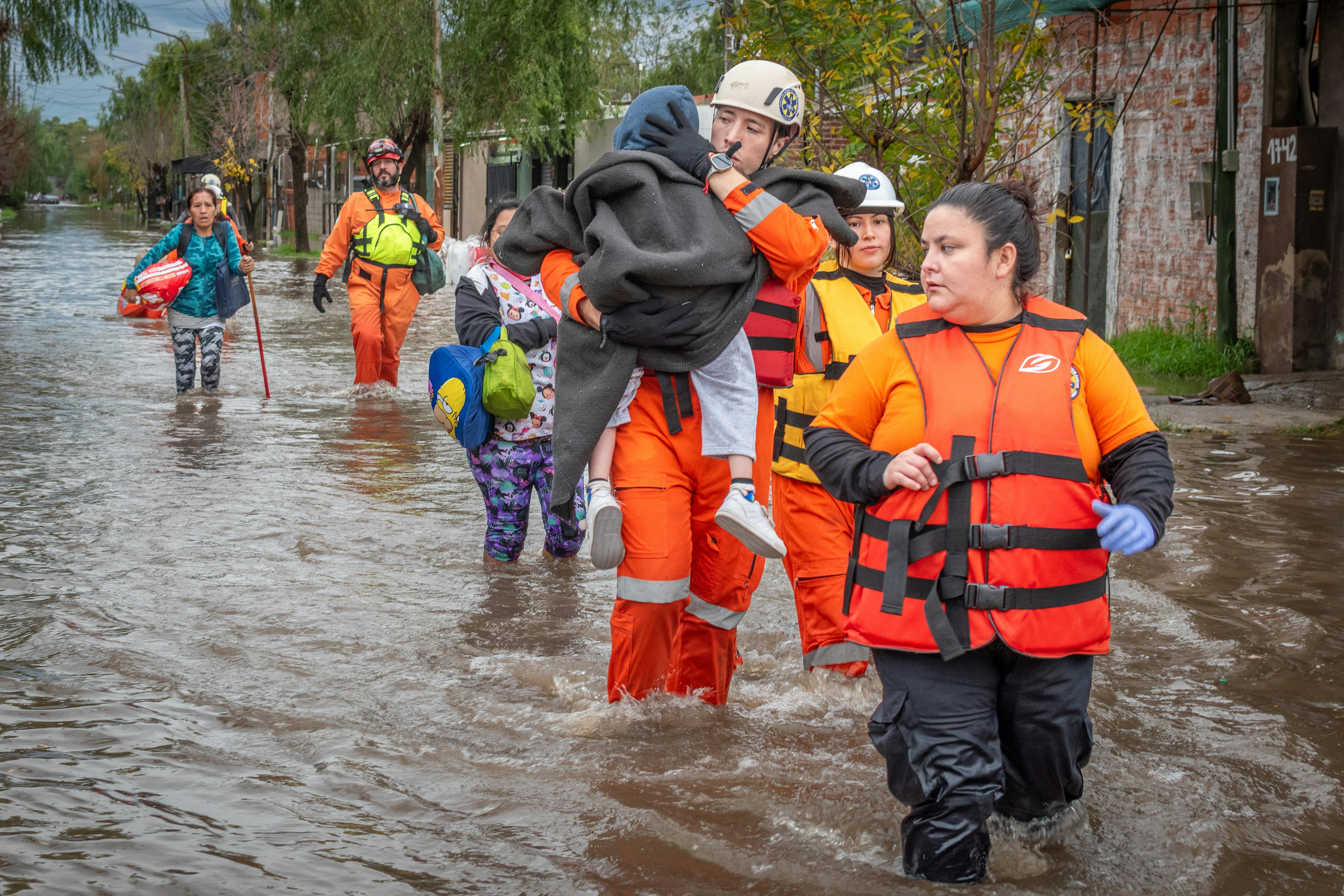
The biggest risks for communities, infrastructure, and the economy

For the southern United States, the most immediate concern is flooding. A wetter El Niño winter can mean repeated rounds of rain over already saturated ground, swollen rivers, flash flooding in urban corridors, and coastal flooding where storms coincide with high tides. Gulf Coast and Southeast cities are especially vulnerable because rapid development has expanded pavement and drainage burdens while heavy downpours have become more costly. Even moderate storms can become disruptive when they arrive in clusters, and El Niño winters are known for favoring just that kind of persistence.
In California and parts of the Southwest, the risk is more complicated than “rain is good” or “rain is bad.” Extra precipitation can recharge reservoirs, improve snowpack in some basins, and temporarily ease drought. But intense bursts of rain can also trigger debris flows on burn scars, overwhelm stormwater systems, damage roads, and threaten homes in foothill and canyon communities. NOAA has emphasized that strong El Niño events often favor wetter conditions along the West Coast, yet the practical hazard comes from how that rain falls: slow and soaking is helpful, while short-duration extremes are destructive.
The economy feels these shifts quickly. Utilities may see unusual demand patterns if the northern tier trends milder while storms hammer the South. Freight rail and trucking routes can suffer delays from washouts, landslides, ice, or repeated severe-weather outbreaks. Agriculture faces a mixed picture as winter wheat, citrus, livestock operations, and specialty crops respond differently to excess moisture, warmth, fungal pressure, and changes in chill hours. Insurance carriers and local governments also bear rising costs when flood claims, road repairs, emergency sheltering, and overtime spending spike in the same season.
Marine ecosystems and fisheries can also feel El Niño’s influence. NOAA notes that along the West Coast, warm El Niño conditions can suppress the normal upwelling of cold, nutrient-rich water, affecting marine food webs and fisheries. That matters not only for commercial fishing communities but for seafood supply chains, tourism, and coastal economies. El Niño is therefore not simply a weather story. It is a systems story, one that touches public health, transportation, water management, food prices, emergency response, and household budgets all at once.
What governments and households should do before winter intensifies
The most effective preparation starts locally. State and municipal agencies should inspect culverts, levees, storm drains, pump stations, and debris basins before the wettest part of winter arrives. Emergency managers should review evacuation routes in flood- and burn-scar-prone areas and update public messaging in multiple languages. School districts, transit agencies, and hospitals should test continuity plans for power disruptions, staffing shortages, and transport delays. These steps are not glamorous, but they are often the difference between a difficult storm and a preventable disaster.
Water managers should use the forecast window to balance opportunity and risk. In regions likely to receive beneficial precipitation, reservoirs and recharge systems may be able to capture more water, but operators must also preserve space for flood control. That requires flexible decision-making, not static rules built for a different climate baseline. El Niño can offer real drought relief in parts of the South and West, as NOAA later noted after El Niño-fueled winter rain helped improve drought conditions in areas around the Gulf Coast during the 2023-2024 cool season. But relief only counts if the water can be stored safely and equitably.
Households should think in practical terms. Flood insurance should be reviewed before a storm is on the horizon, because waiting periods can apply. Residents in vulnerable neighborhoods should clear drains, document property conditions, move valuables above ground level where possible, and assemble supplies for several days without reliable power or travel. People in wildfire burn zones should pay special attention, since heavy winter rain can trigger mudslides and debris flows months after the flames are gone. Preparation is not fear-driven when it is specific, affordable, and tied to known local hazards.
Businesses should also prepare for supply and staffing interruptions. Retailers, food distributors, construction firms, and health systems can all benefit from contingency planning for delayed shipments, employee travel problems, and short-notice closures. The broader principle is simple: treat a high-confidence El Niño forecast the way you would treat a hurricane season outlook or a severe heat warning. It does not tell you the exact day trouble will arrive, but it does tell you the probability environment has changed enough to justify action now.
The larger climate lesson: preparation beats prediction alone

El Niño is often framed as a spectacle of natural variability, and it certainly is that. But the more important public lesson is how a recurring climate pattern interacts with a warming world and increasingly fragile infrastructure. NOAA’s global and national assessments have shown that recent years have been exceptionally warm, with marine heatwaves and record or near-record ocean temperatures adding energy to the climate system. When El Niño develops on top of that background warmth, the consequences can extend beyond familiar seasonal averages into more expensive extremes.
That does not mean every flood, drought, or warm spell can be blamed on El Niño. Good climate communication avoids that trap. What forecasters can say with confidence is that El Niño shifts the odds, and societies that understand odds are better prepared than societies that wait for certainty. The same forecast that helps a meteorologist anticipate a wetter Gulf Coast winter can help a mayor pre-position pumps, a farmer adjust planting and drainage decisions, or a family review whether their home is exposed to runoff and creek flooding.
There is also a governance lesson here. Forecast skill has improved enough that warnings can come months in advance, but institutions still struggle to convert climate information into action. Too often, preparation is underfunded until after roads wash out, reservoirs spill, or neighborhoods flood. The existence of a high-probability El Niño outlook should push federal, state, and local officials to act earlier, not merely issue statements. A good forecast has limited value if procurement delays, staffing gaps, or fragmented authority prevent response.
The bottom line is clear. A 90% or better chance that El Niño will persist through winter is not a curiosity for weather enthusiasts; it is an actionable signal for the United States. NOAA and the WMO have made clear that the pattern can strongly influence winter precipitation and temperature, especially across the South and along parts of the West Coast. The country does not need alarmism, and it does not need false certainty. It needs disciplined preparation, region by region, while there is still time to reduce damage before winter’s biggest tests arrive.