

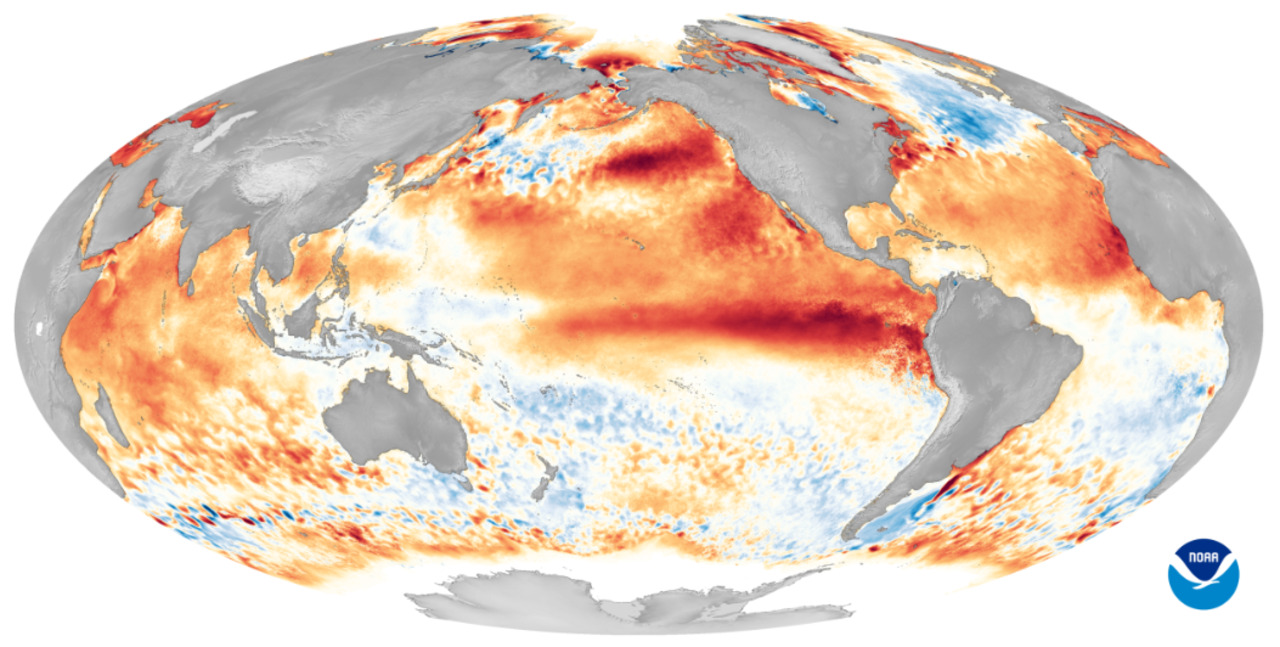
NOAA’s latest Atlantic hurricane outlook says the 2026 season is now most likely to finish below normal, a major shift from the recent run of hyperactive years. But the quieter basin-wide forecast does not mean risk is evenly reduced, and the areas with the warmest water still matter most for residents along vulnerable coasts. El Niño is changing how forecasters assess the season, especially across the Gulf, Caribbean and western Atlantic where storms can still organize quickly.
NOAA lowers the basin-wide outlook as El Niño strengthens
NOAA updated its 2026 Atlantic hurricane season outlook on August 6 and said a below-normal season is now the most likely outcome, with an 55% chance of below-normal activity, a 35% chance of near-normal activity and only a 10% chance of an above-normal season, according to the Climate Prediction Center. The agency’s forecast calls for 8 to 14 named storms, 3 to 6 hurricanes and 1 to 3 major hurricanes for the season that runs from June 1 through November 30. NOAA said the outlook was produced with the National Hurricane Center and Atlantic Oceanographic and Meteorological Laboratory.
The main driver is El Niño. NOAA’s Atlantic outlook says El Niño is expected to increase vertical wind shear over the tropical Atlantic, a pattern that typically disrupts storm formation and limits how easily systems can organize and strengthen. A NOAA explainer published June 2 said that added shear is the primary reason forecasters expect fewer Atlantic hurricanes this year.
That broader outlook has become more confident as Pacific conditions have intensified. The Climate Prediction Center’s ENSO Diagnostic Discussion issued July 9 said El Niño was already in place, was strengthening, and had a 97% chance of lasting through early spring 2027. The same discussion said there was an 81% chance of a very strong El Niño during October through December, a signal that has weighed heavily on hurricane outlooks this summer.
Forecasters have also stressed what the seasonal outlook does not say. NOAA states plainly that its hurricane outlook is not a landfall forecast and does not predict activity for any particular location, meaning no state or coastline can be ruled out simply because the basin-wide totals are lower. That remains a critical point for residents from Texas to Florida and north along the Atlantic coast.
What is confirmed is that some parts of the Atlantic side of the basin are still running warm even as El Niño suppresses activity overall. National Weather Service offices citing NOAA’s seasonal outlook have said sea surface temperatures remain slightly above normal across the tropical and subtropical Atlantic, including the Gulf and Caribbean. Those areas matter because storms that form close to land can have less time to weaken and less distance to travel before threatening coastal communities.
That helps explain why forecasters are watching the western side of the basin closely even in a quieter year. The Main Development Region farther east may be less favorable when wind shear is elevated, but the Gulf, Caribbean and waters near the U.S. East Coast can still support development if short-term weather patterns briefly turn favorable. NOAA has not released a comprehensive state-by-state risk ranking for 2026.
The science behind the shift is well established. NOAA and AOML say El Niño changes upper-level winds across the Atlantic, increasing vertical wind shear that can tear apart thunderstorms before they consolidate into tropical cyclones. That is why El Niño years often produce fewer Atlantic storms than La Niña years, even when ocean temperatures in parts of the basin remain supportive.
At the same time, NOAA’s outlook notes that the Atlantic is still in an ongoing high-activity era that began in 1995, and some supportive background conditions remain in place. The agency said warmer waters in the Atlantic hurricane Main Development Region and other favorable large-scale patterns were expected to continue in 2026, just not strongly enough to overcome El Niño’s suppressing effect across the basin as a whole.
For residents, the practical message is narrower than the headline seasonal numbers. A lower storm count does not eliminate local danger, particularly in the Gulf, Caribbean and western Atlantic where warm water can still support rapid development near land. NOAA’s position remains that seasonal outlooks cannot determine where a storm will strike, and that uncertainty will continue through the peak months of August, September and October.