
The warning is urgent, and the setup is familiar in the worst possible way. Across parts of the West, the atmosphere is lining up for rapid fire growth before many people have finished their morning routines.
Why today’s warning matters so much

NOAA’s fire weather alerts are not routine boilerplate. When the National Weather Service issues a Red Flag Warning, it means forecasters expect a dangerous overlap of strong wind, very low humidity, and dry fuels—conditions that can help a small ignition become a serious wildfire in a matter of minutes. The agency’s national fire weather page makes clear that these warnings are reserved for periods when critical fire weather conditions are occurring or will begin shortly, and local forecast offices use criteria tailored to the vegetation and terrain in their areas. According to the National Weather Service, that combination is the threshold that matters most for firefighters and emergency managers because it signals elevated potential for extreme fire behavior.
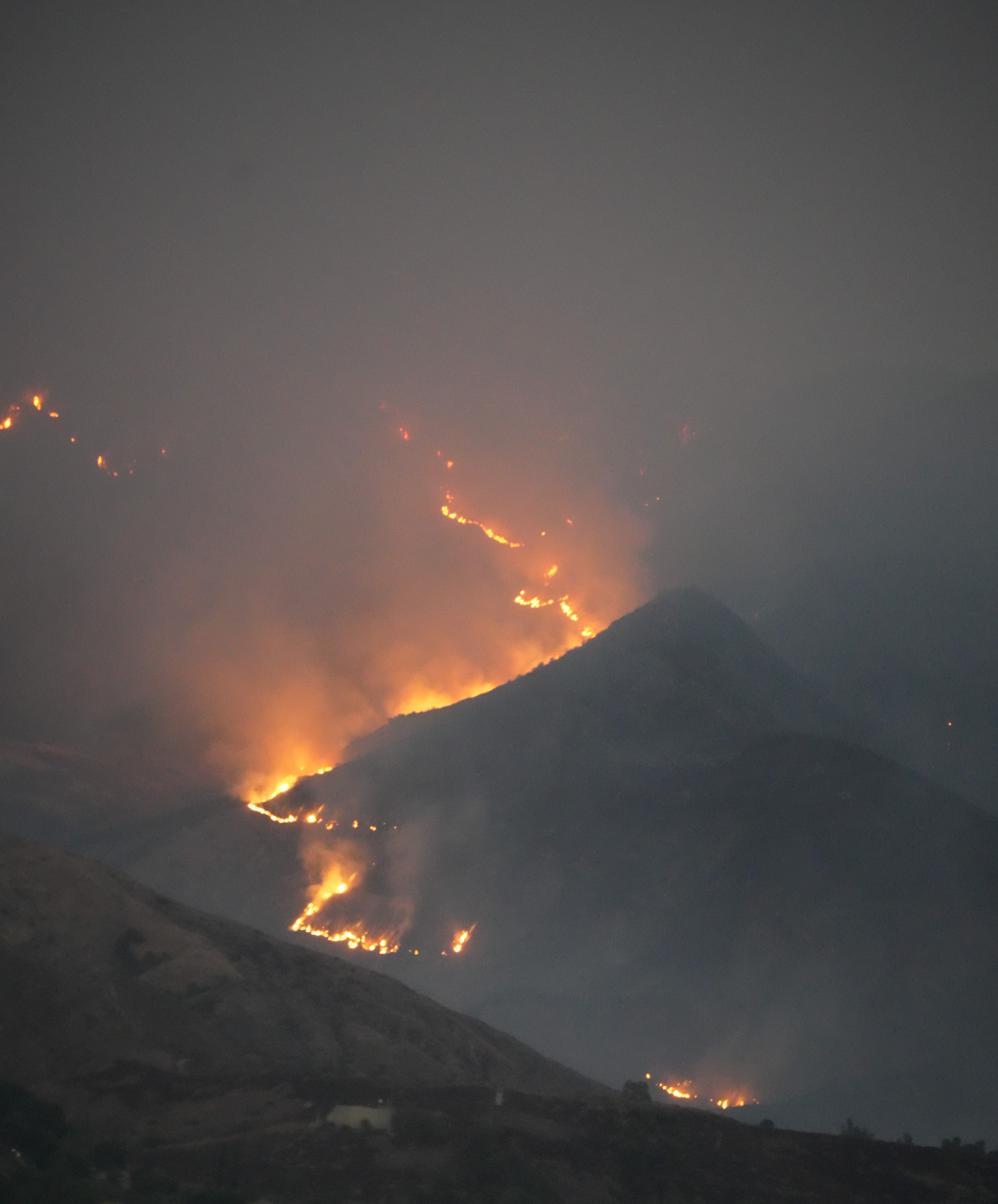
What makes today especially concerning is that these warnings are not isolated to one small pocket. A Red Flag Warning posted by the Sacramento office covers parts of the northern Sacramento Valley through Thursday afternoon, with north winds of 15 to 25 mph, gusts of 30 to 40 mph, and minimum humidity between 9% and 15%. The warning explicitly says the highest threat is along and west of the Interstate 5 corridor and warns that fires can rapidly grow in size and intensity. That language is direct because the forecast ingredients are already in place, not merely hypothetical.
Farther inland, recent Red Flag Warning statements from the Denver/Boulder region and neighboring High Plains forecast areas describe similarly volatile conditions, including west to southwest winds of 15 to 35 mph, gusts reaching 50 mph, and humidity as low as 8% to 12%. Some alerts also mention the added risk of dry lightning, a particularly dangerous trigger because it can ignite remote fuels while winds are already primed to spread flames. Taken together, these alerts show a broad regional pattern rather than a one-off event.
That matters because the national backdrop is already growing more active. The National Interagency Fire Center has reported that the country reached Preparedness Level 2 this season, indicating light overall activity but increasing fire potential in some regions and a greater need to watch resource availability closely. In practical terms, that means today’s fire weather threat is arriving at a moment when agencies are already tracking a more active landscape, especially in the interior West.
The weather ingredients are already turning dangerous
The most important detail in any fire weather warning is not just the temperature. Fire spread is often driven more aggressively by the relationship between wind, humidity, and fuel dryness than by heat alone. A day in the 80s or 90s with steady gusts and single-digit or low-teen relative humidity can be far more dangerous than a hotter but calmer day. That is why today’s forecast package is so concerning across several western states: the air is drying quickly, afternoon heating will deepen mixing, and winds are expected to strengthen as the day progresses.
In Albuquerque, for example, the forecast shows temperatures climbing from the upper 60s in the morning to the mid-90s by late afternoon and evening. In Phoenix, the expected rise is even more punishing, with temperatures reaching roughly 107°F to 108°F during peak afternoon hours. On their own, those numbers are a public health concern. Layered onto dry fuels and regional wind events, they become part of a fire behavior problem that can quickly overwhelm initial attack if an ignition occurs in the wrong place.
Even areas that are not under the hottest readings can still be vulnerable. Northern California’s Red Flag Warning is focused less on extreme heat than on the classic wind-and-humidity combination that often drives rapid runs in grass and brush. That is an important reminder for the public: wildfire danger does not require record-breaking temperatures. It requires receptive fuels and weather that supports ignition and spread, and that setup is exactly what forecasters are describing today.
The timing also raises the stakes. Fire weather usually worsens from late morning into evening as humidity bottoms out and winds mix down to the surface. That means the hazard can intensify while people are outside mowing, towing trailers, using equipment, or traveling through dry corridors where a spark can escape unnoticed. When forecasters say conditions are either occurring now or will begin shortly, they are warning that the atmospheric runway for fire growth is already open.
Where the threat is highest and who should pay closest attention

The areas drawing the most concern today are parts of Northern California, the central Rockies, the High Plains, and portions of the broader Southwest. In the Sacramento warning area, forecasters singled out valley locations with exposed terrain and low humidity, noting that the highest threat sits along and west of the Interstate 5 corridor. In Colorado and adjacent plains zones, recent warning language points to large stretches of open country where wind can move uninterrupted across cured grasses and receptive brush. Those landscapes can support fast rates of spread even when flames start small.
Rural residents are often the first to think about wildfire, but they are not the only people at risk during a Red Flag Warning. Suburban communities on the edge of grassland, foothill neighborhoods, long-haul drivers on dry corridors, utility crews, farm operators, and construction teams all have exposure during this kind of event. A chain dragging from a trailer, a hot vehicle parked over dry grass, target shooting, welding, debris burning, or even a roadside spark can become the ignition source when the air mass is this unstable from a fire perspective. That is why warnings routinely emphasize avoiding outdoor burning and any activity that may create sparks.
Fire agencies also look beyond the current map of warnings to the broader seasonal pattern. The National Interagency Fire Center’s outlooks and preparedness framework exist because weather danger is only one part of the equation; resource strain matters too. When multiple geographic areas begin seeing elevated potential at once, aircraft, crews, and incident teams can become harder to move quickly. Preparedness Level 2 does not mean the nation is in severe crisis, but it does indicate a more watchful posture as fire potential begins to increase.
For the public, the takeaway is straightforward: if you live anywhere near dry grass, brush, timber edges, canyons, or wind-prone open terrain, this warning applies to you whether or not flames are visible nearby. Fire weather events are dangerous precisely because they create the conditions for the first fire to become the next emergency. By the time smoke is visible from a highway or neighborhood, the most important prevention window may already have closed.
What firefighters and emergency managers are watching right now
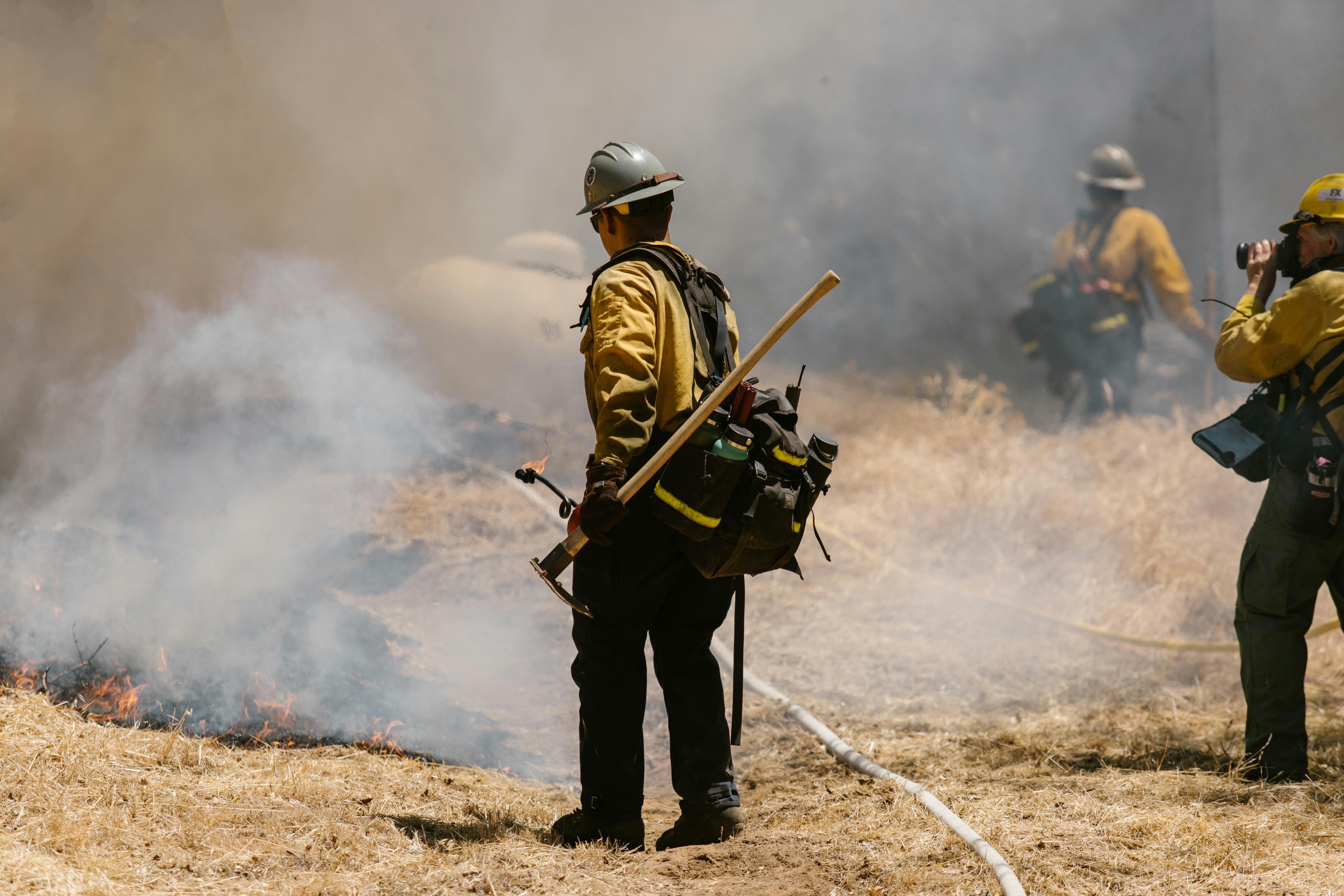
When meteorologists issue a critical fire weather warning, fire agencies immediately begin thinking in operational terms. They are not simply asking whether a fire can start; they are asking how quickly one could escape initial attack, what values are exposed, and how many simultaneous starts could stretch local resources. Winds in the 20 to 40 mph range with stronger gusts are especially troubling because they can push flames through grass and light brush faster than ground crews can flank them, while also lofting embers well ahead of the fire front. That spotting behavior is often what turns a manageable incident into a campaign fire.
Humidity is another key operational signal. Once relative humidity drops into the single digits or low teens, fine fuels such as grasses, weeds, pine needles, and small twigs become far easier to ignite and can carry fire rapidly. Several of today’s warning statements cite humidity values between 8% and 15%, which is well within the range that raises concern for aggressive surface fire behavior. In some warning areas, poor overnight recovery is also a problem because fuels do not regain much moisture before the next afternoon’s wind and heat return.
Emergency managers are also watching the human side of the equation. Thursdays and Fridays can be particularly sensitive in some regions because more travel, outdoor work, and recreation start to build ahead of the weekend. If a warning overlaps with roadside traffic, agricultural activity, utility work, or recreation on public lands, the chance of human-caused ignitions can rise significantly. The National Interagency Fire Center has repeatedly emphasized that preventing human-caused fires is a shared responsibility, a message that becomes more urgent on days like this.
Another concern is compounding hazards. Some recent warning products note the possibility of dry lightning, which can ignite new fires in rugged or remote areas where access is slow. Others are focused on wind-driven grass fire potential in valleys and plains where flames can move quickly toward roads, structures, and utility corridors. Firefighters do not need a record-setting mega-drought on a single day to face a dangerous situation; they need one unstable weather window and one ignition in the wrong fuels. Today offers too many chances for that combination.
What people should do for the rest of the day

The most effective public response to a Red Flag Warning is simple restraint. Do not burn debris, do not use equipment that throws sparks, and do not assume a small flame can be controlled if something goes wrong. Activities that seem ordinary on calmer days—grilling near dry grass, parking a hot car off pavement, dragging trailer chains, welding outdoors, using a mower in cured vegetation—can become ignition sources during critical fire weather. The warning language from multiple National Weather Service offices is blunt for a reason: outdoor burning is not recommended, and any fire that develops may spread rapidly.
People in or near fire-prone areas should also shift into readiness mode even if no evacuation has been issued. That means keeping phones charged, reviewing multiple ways out of the neighborhood, moving flammable materials away from structures, and making sure vehicles have fuel. If you rely on medical equipment, need extra time to leave, or have livestock, that planning should happen early in the day rather than after smoke appears. Fast-moving fires often erase the luxury of waiting for perfect information.
For travelers, the best habit is constant awareness. If you see smoke, emergency vehicles, or sudden road closures, do not stop to watch. Keep clear of shoulders and access roads that firefighters may need, and report any visible roadside fire immediately. In warning areas, even a small patch of flame in grass should be treated as time-sensitive because wind can outrun casual assumptions faster than most people realize. That is particularly true in exposed valleys, plains, and foothill routes where fire has room to run.
The broader lesson from today’s NOAA warning is that dangerous fire days are not defined by dramatic images alone. They begin with ordinary decisions made under extraordinary weather. By the afternoon, parts of the West will be dealing with hot temperatures, very low humidity, and gusty winds at the same time, while the national fire system is already in a heightened monitoring posture. That is exactly when prevention matters most—before the first column of smoke rises, not after.